The Atlantic tropics are showing signs of becoming increasingly dangerous as a powerful storm system continues to organize and strengthen. Weather experts are closely monitoring a rapidly developing cyclone moving through the Caribbean, warning that it has the potential to become a highly destructive hurricane. Fueled by exceptionally warm ocean waters, the system is gaining strength and could pose a significant threat to coastal communities in the coming days. Authorities are urging residents in potentially affected areas to begin preparations early and stay alert to rapidly changing forecasts.
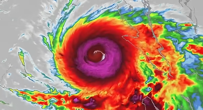
The National Hurricane Center has issued important advisories regarding Potential Tropical Cyclone Nine, a disturbance that forecasters expect to develop into Tropical Storm Helene and possibly strengthen into a major hurricane shortly thereafter. At present, the system is generating widespread thunderstorms across the northwestern Caribbean. Satellite observations indicate that a more organized circulation center is gradually taking shape, a critical step in the storm’s development. Once this center becomes fully established, meteorologists believe the system could intensify at a much faster rate due to favorable atmospheric conditions and unusually warm waters along its projected path.
Weather specialists are carefully analyzing every update, looking for signs that the disturbance is becoming a fully organized tropical storm. Forecasts suggest that Helene will move northward through the Yucatán Channel over the next one to two days before entering the Gulf of Mexico. This region is known for providing conditions that can support significant hurricane strengthening, and current projections indicate that the environment may be especially favorable for additional development. As a result, forecasters remain concerned that the system could evolve into a much more dangerous and impactful storm.
Current model guidance points toward a track that could bring Helene toward the Florida Panhandle or portions of Florida’s west coast later in the week. However, meteorologists stress that even small shifts in the storm’s path could dramatically alter which communities experience the most severe effects. Residents throughout Florida and neighboring southeastern states are encouraged to monitor forecasts closely, as changes in track or intensity remain possible. Several forecast scenarios indicate that the system may reach hurricane strength before landfall, with some projections suggesting it could become a Category 2 or even Category 3 hurricane if strengthening continues.
The threats associated with this storm extend well beyond powerful winds. Heavy rainfall, coastal storm surge, and widespread flooding are expected to be among the most serious hazards. Emergency officials are particularly concerned about the possibility of flash flooding in inland locations, even far from the storm’s center. Outer rain bands can produce dangerous weather conditions over a large area, meaning communities not directly in the storm’s path may still face significant impacts. This broad range of potential hazards makes the storm a concern for much of the southeastern United States.
Residents in Florida, Georgia, and South Carolina are being advised to review weather updates frequently and remain prepared for changing conditions. Hurricanes can strengthen unexpectedly, making timely information essential for protecting lives and property. Emergency management agencies recommend reviewing evacuation plans, identifying safe shelter locations, and ensuring emergency supply kits are ready. Taking these precautions early can make a critical difference if conditions worsen.
People in areas that could be affected should begin gathering necessities such as bottled water, non-perishable food, medications, flashlights, batteries, and backup power supplies. Officials continue to emphasize the importance of following instructions issued by local authorities and remaining prepared to act if evacuation orders become necessary. Because tropical systems can change rapidly, residents should stay informed and be ready to respond quickly. Monitoring trusted weather sources and following emergency guidance will remain essential as Helene continues its development and moves closer to land. Meteorological agencies will continue tracking the storm around the clock, and everyone in potentially affected regions is encouraged to take the threat seriously and prepare accordingly.