For 20 Years, an Eagle Equipped With GPS Puzzled Scientists — The Real Story Behind the Viral Map
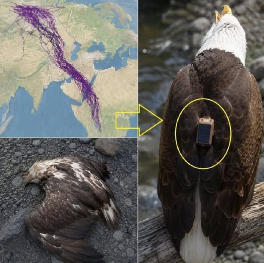
A remarkable map showing tangled lines across Europe, Asia, and the Middle East has fascinated nature lovers for years. Social media posts claim that the lines trace the extraordinary 20-year journey of a single eagle equipped with a GPS tracker.
The story sounds incredible: one bird traveling thousands of miles, navigating mountains and deserts, and repeatedly avoiding vast stretches of open water.
But the truth behind the image is even more interesting because it reveals how modern technology helps scientists understand bird migration.
The Mystery Behind the Lines
At first glance, the map looks like a complicated web of flight paths. The lines stretch across multiple countries, bend around coastlines, and connect distant regions.
Many online posts describe the image as the lifelong journey of one eagle, claiming that scientists tracked the bird for two decades.
However, fact-checkers investigating the image discovered that this explanation was misleading.
The map actually represents the movements of approximately 20 steppe eagles tracked over about 10 months in 2018, rather than one bird traveling for 20 years. A misunderstanding during the circulation of the image helped the incorrect story spread online.
Why Did the Eagles Avoid Large Bodies of Water?
One striking feature of the migration routes is that the birds often traveled around large bodies of water instead of crossing them directly.
There is a scientific explanation for this behavior.
Large soaring birds rely heavily on rising columns of warm air, known as thermals, to gain altitude and travel long distances while conserving energy.
Thermals form more readily over land than over large expanses of water. When crossing open water, soaring birds may have fewer opportunities to gain altitude without flapping their wings, making certain routes more energetically demanding.
As a result, flying around a sea can sometimes be a safer or more efficient option than taking the shortest route across it.
What GPS Tracking Reveals About Wildlife
Satellite tracking has transformed the study of bird migration.
Instead of relying only on sightings or occasional observations, researchers can record locations and reconstruct the journeys of individual birds over time.
These data help scientists identify important migration corridors, investigate how birds respond to environmental conditions, and determine which areas may need protection.
For threatened species such as the steppe eagle, understanding migration routes can be particularly valuable because the birds travel through many different countries and landscapes.
The Real Lesson Behind the Viral Story
The claim that a single eagle was tracked for 20 years may be inaccurate, but the underlying science is genuinely fascinating.
The map demonstrates how multiple birds navigate enormous distances and how geography influences their movements.
It also offers an important reminder about information shared online: an extraordinary photograph can be authentic even when the story attached to it is not.
Sometimes, the truth does not make a discovery less remarkable. It simply helps us understand what we are really looking at.
The real achievement is not one eagle flying for 20 years under a GPS tracker. It is the ability of modern science to reveal the incredible journeys of migratory birds across continents.