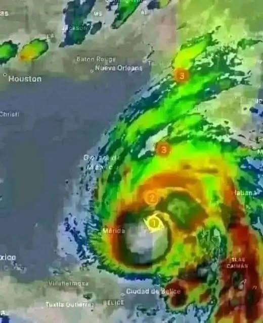
The National Hurricane Center (NHC) has issued its first advisories on what is currently called Potential Tropical Cyclone Nine, a storm system developing rapidly in the northwestern Caribbean. Forecasters are warning that this system will likely organize into Tropical Storm Helene within the next 24 hours. As it strengthens, it is expected to track through the Yucatán Channel and enter the Gulf of Mexico, where warm waters could allow it to intensify quickly into a powerful hurricane.
Meteorologists are urging residents in Florida, Georgia, and South Carolina to pay close attention to advisories. Current models suggest that by Thursday, Helene may be approaching the Florida Panhandle or the west-central coast of Florida as a Category 2 or possibly Category 3 hurricane. If this forecast holds, the system could bring destructive winds, storm surge flooding, and torrential rainfall to a wide swath of the southeastern United States.
The storm’s current structure is still disorganized, with clusters of thunderstorms scattered across the Caribbean. However, satellite imagery shows signs that circulation is tightening and convection is becoming more consistent—an indication that the storm is consolidating. Once a defined center forms, the NHC will formally classify it as a tropical storm, giving it the name Helene.
Why This Storm Is Dangerous
While it is still too early to predict exact landfall, forecasters emphasize the broad potential impact of this system. Unlike compact hurricanes that strike with focused destruction, storms like Helene often develop large wind fields. That means strong winds and heavy rain can extend hundreds of miles from the center, affecting multiple states at once.
The Gulf of Mexico, particularly in late September, is notorious for fueling rapid intensification. Warm sea surface temperatures combined with relatively light wind shear create an environment where tropical systems can explode in strength in just a matter of days. That is why officials are warning that Helene may not remain a “minor” storm for long. Once it crosses the Yucatán Channel, it will have an open runway of warm water and atmospheric support to strengthen significantly.
Storm surge is another grave concern. Even a Category 2 hurricane can push walls of seawater into coastal communities, overwhelming defenses and endangering lives. Given the geography of Florida’s Gulf Coast, low-lying areas are particularly at risk. Residents along bays, inlets, and barrier islands may be urged to evacuate if forecasts hold.
Historical Lessons
This is not the first time the Gulf Coast has faced a storm of this nature. Hurricanes Michael, Katrina, and Ian all began as relatively modest systems before rapidly intensifying in the warm waters of the Gulf. The lessons from those storms are clear: do not underestimate the potential for explosive growth, and do not wait until the last minute to prepare.
Forecasters are careful not to overstate the threat too early, but the historical pattern is sobering. Rapid intensification has become increasingly common in recent years, leaving less time for communities to evacuate or make preparations. That is why the NHC begins issuing advisories even before a system officially qualifies as a tropical storm—early awareness can save lives.
What Residents Should Do Now
Emergency managers stress that preparation should begin immediately, even before the storm is named. Households should review evacuation plans, check emergency supply kits, and ensure they have enough food, water, medications, and essential supplies to last at least several days. Batteries, flashlights, and portable chargers are critical in case of widespread power outages.
Officials also advise securing outdoor furniture, trimming trees, and clearing drains to minimize damage from winds and flooding. For those living in evacuation zones, it is important to know routes and shelters in advance rather than scrambling at the last moment. Gas tanks should be kept full, and important documents should be stored in waterproof containers.
Perhaps most importantly, residents are reminded not to fixate solely on the projected “cone of uncertainty.” Impacts from tropical systems often extend far outside the central forecast track. Heavy rainfall, tornadoes, and flash flooding can occur hundreds of miles away from landfall.
The Forecast Track
Current models suggest that Helene will likely form in the northwestern Caribbean before moving northward through the Yucatán Channel. From there, the system is expected to bend northeastward into the Gulf of Mexico. Depending on steering currents, landfall could occur anywhere from the Florida Panhandle to west-central Florida. After crossing into the Southeast, heavy rain bands may sweep through Georgia and South Carolina, with potential impacts even further inland.
The NHC will continue updating the forecast as more data becomes available, including from hurricane hunter aircraft flights into the system. These missions provide critical real-time information about wind speeds, pressure, and storm structure, helping improve track and intensity predictions.
Broader Implications
For communities already weary from a busy hurricane season, Helene’s potential arrival is another reminder of the growing unpredictability of tropical storms. Warmer oceans and shifting climate patterns appear to be fueling more frequent rapid-intensification events, giving coastal residents less time to react.
If Helene does reach Category 3 status, it would rank as a major hurricane, capable of catastrophic damage. Even if it peaks at Category 2, the combination of storm surge, widespread power outages, and flooding rainfall could disrupt lives for weeks. Agricultural regions, already strained by heavy rains earlier in the year, may face additional crop losses. Tourism, a major economic driver in Florida, will also be disrupted during one of its peak seasons.
A Community on Edge
Local governments are already beginning to mobilize. Emergency operations centers in Florida are monitoring developments closely, and residents are hearing familiar reminders: prepare early, stay informed, and take evacuation orders seriously. Shelters are being readied, and hospitals are reviewing emergency protocols in anticipation of possible surges in patients after the storm.
Social media is buzzing with speculation and concern, but officials urge residents to rely on official sources like the NHC and local emergency management offices for accurate updates. Rumors and misinformation spread quickly during storm events, which can be as dangerous as the storm itself.
Additional Warnings and Concerns
Meteorologists are emphasizing that Helene could interact with other weather systems already in the Atlantic, potentially creating unpredictable shifts in track and intensity. The presence of upper-level troughs or high-pressure systems could steer Helene closer to the coast or slow its progress, increasing rainfall totals.
Emergency planners are particularly concerned about the potential for tornado outbreaks along the storm’s outer bands. Even moderate hurricanes have spawned deadly tornadoes far inland, making preparation in regions well beyond the coast critical.
Communication lines and disaster relief coordination are also under review. Utility companies are pre-positioning crews to restore electricity quickly, while local governments are arranging temporary shelters and evacuation routes. Lessons from past storms show that the speed of response can significantly reduce injuries and fatalities.
Preparedness for Businesses
Businesses along the projected path are being advised to secure premises, protect inventory, and prepare for interruptions in operations. Flood-prone retail districts may need to elevate equipment or temporarily relocate valuable assets. Essential services, such as hospitals and emergency responders, are checking supply chains and backup systems to ensure continuity during potential outages.
Insurance providers are also reminding residents to review coverage, understand deductibles, and document property with photographs. Swift claims processing in the aftermath of a hurricane can be crucial for families and businesses recovering from physical and financial damage.
Impact on Travel
Airlines and transport services are monitoring the storm closely. Delays and cancellations are possible, especially along Florida’s west coast and Gulf states. Cruise lines are adjusting itineraries to avoid rough seas, and ports are reviewing emergency procedures for ships in the hurricane’s path.
For residents planning trips, it is advised to reconsider nonessential travel and follow guidance from the Department of Transportation and local authorities. Flooded roads and downed trees can make travel extremely hazardous even after the storm passes.
School Districts and Education
Several school districts in Florida, Georgia, and South Carolina are preemptively announcing closures or virtual learning days to keep children safe. Parents are urged to monitor official channels for updates, and after-storm recovery plans will be activated to ensure that education continues safely.
Local universities are also issuing alerts for students, faculty, and staff, reminding everyone of evacuation procedures, emergency shelters, and the importance of keeping emergency kits on hand.
Community Support and Volunteerism
Civic organizations are mobilizing volunteers to assist with evacuations, deliver supplies, and support vulnerable populations. Faith-based groups and local nonprofits are coordinating food, water, and medical supplies, particularly for senior citizens and residents with mobility challenges.
Volunteer registration and safety briefings are being emphasized to ensure that efforts are organized and effective, minimizing risk to those offering help as well as recipients.
Climate and Environmental Observations
Scientists are paying close attention to Helene for research on storm patterns and climate change. The rapid intensification of tropical systems like this one provides valuable data on oceanic heat content, atmospheric conditions, and potential links to global warming.
Such observations help inform future forecasting, improve early-warning systems, and contribute to better planning for communities prone to hurricanes.
Media and Public Information
News outlets are coordinating with emergency management to provide consistent messaging. Special segments, live updates, and emergency hotlines are being prioritized. The goal is to keep misinformation to a minimum and ensure residents have timely, accurate, and actionable information.
Community forums, radio alerts, and social media advisories are being used to reach remote or underserved areas, increasing preparedness across the board.
Conclusion
Potential Tropical Cyclone Nine is not yet a named storm, but all signs point to it becoming Tropical Storm Helene within the next day. If forecasts hold, it will strengthen further into a hurricane as it approaches Florida by Thursday, threatening not only the Sunshine State but also Georgia and South Carolina with wind, flooding, and storm surge.
The message from experts is clear: do not wait. Prepare now, stay tuned to official advisories, and be ready to act. The days ahead could determine not only the storm’s path but also the safety of millions of people living along the southeastern coast of the United States.
Helene has not yet fully formed, but the time to take it seriously is now.