The atmosphere across the city has shifted from a calm afternoon to a state of high alert as meteorologists and emergency management officials track a powerful, fast-moving severe thunderstorm advancing with alarming speed. This is not just a routine seasonal disturbance; radar imagery has revealed a highly organized and volatile storm cell characterized by intense internal dynamics. The system is currently barreling toward the metropolitan area, bringing the potential for life-threatening conditions, including destructive straight-line winds, torrential downpours, and a nearly continuous barrage of cloud-to-ground lightning. As the leading edge of the storm approaches, the sky has taken on an ominous, bruised hue, serving as a visual precursor to the atmospheric violence about to be unleashed.
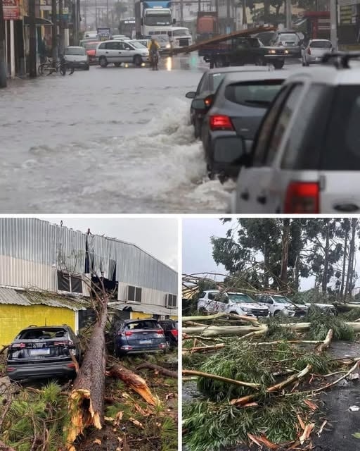
Local weather bureaus have classified this system as an imminent threat, warning that the storm’s rapid acceleration means the window for preparation is closing fast. The primary concern for public safety is the anticipated wind gusts, which may exceed thresholds capable of uprooting mature trees and snapping utility poles. Such force poses an immediate danger to residential structures and vehicles, particularly in older neighborhoods with significant tree canopies. Furthermore, the sheer volume of moisture being carried by this system suggests that rainfall rates could overwhelm urban drainage systems within minutes, creating a high probability of flash flooding in low-lying areas, underpasses, and arterial roads, turning standard commutes into treacherous navigational challenges.
Emergency services have been placed on high alert, and officials are urging residents to prioritize their immediate safety by moving indoors and away from windows. The frequency of lightning strikes within this cell is particularly high, posing a lethal risk to anyone caught in open spaces, on athletic fields, or near bodies of water. The advice from the Department of Public Safety is unequivocal: if you can hear thunder, you are close enough to be struck. Residents are encouraged to spend these final moments before the storm hits securing loose outdoor furniture, trash bins, and any other items that could become airborne projectiles in high winds. Securing the exterior of a home is a critical step in mitigating property damage and preventing secondary injuries to neighbors.
For those currently on the road, the directive is to seek shelter immediately. Driving during the peak of such a severe thunderstorm is a gamble against rapidly deteriorating visibility and unpredictable road hazards. Flash flooding can occur so suddenly that drivers may find themselves stranded in rising waters before they can safely exit their vehicles. Additionally, the risk of hydroplaning and the presence of fallen debris—such as large branches or downed power lines—make the roads a primary site for accidents during these events. If you are caught in transit, the safest course of action is to pull over into a sturdy parking structure or a location away from tall trees and wait for the core of the storm to pass. Under no circumstances should anyone attempt to drive through flooded roadways, as even a few inches of moving water can exert enough force to sweep a vehicle off its path.
Beyond the immediate physical dangers, the city is bracing for the likelihood of significant infrastructure disruptions. Utility companies have mobilized repair crews in anticipation of widespread power outages. As the wind tears through the electrical grid, residents should be prepared for the loss of lights, climate control, and internet connectivity. It is highly recommended that all mobile devices be fully charged immediately and that emergency kits—containing flashlights, fresh batteries, and basic first-aid supplies—be kept in an easily accessible location. In the digital age, staying informed is vital, and residents are urged to utilize battery-powered weather radios or smartphone apps that provide real-time alerts to track the storm’s progress and receive any further emergency instructions from city hall.
The psychological impact of such sudden, intense weather events can be significant, especially for vulnerable members of the community. In the final minutes of calm, residents are asked to perform a quick “safety check” on elderly neighbors, individuals with mobility issues, or those living alone. A brief phone call or a knock on the door can ensure that everyone in the community is aware of the incoming danger and has a plan to reach a safe interior room. For families with pets, now is the time to bring animals inside and provide them with a secure space, as the loud claps of thunder and the high-pitched whistle of the wind can cause severe distress and lead to flight instincts.
As the storm moves closer, the temperature is expected to drop sharply, accompanied by a noticeable increase in pressure. These sensory cues are the final warnings for the public to move into a “shelter-in-place” posture. The safest location in most homes is an interior room on the lowest floor, such as a bathroom, closet, or hallway, away from exterior walls and glass. Avoiding the use of corded electronics and plumbing during the peak of the lightning activity is also a standard safety precaution, as electrical surges can travel through a building’s wiring or pipes.
Meteorologists are continuing to analyze the storm’s trajectory, noting that while the system may move through the city with relative speed, the intensity of its passage could leave a lasting mark on the landscape. Once the initial line of storms has passed, the danger does not immediately subside. Residents must remain cautious of “hidden” hazards such as weakened tree limbs that may fall hours after the wind has died down, or electrified puddles caused by downed “live” wires. Approaching any downed utility line is strictly forbidden, and any such sightings should be reported to emergency dispatchers immediately.
The city has weathered severe systems before, but the unique combination of the current storm’s speed and its high energy levels requires a heightened level of communal vigilance. By acting now—by staying informed, staying indoors, and looking out for one another—the residents of the city can significantly reduce the potential for tragedy. The goal of these urgent alerts is not to cause panic, but to foster a state of readiness that prioritizes the sanctity of human life over the inconvenience of a disrupted schedule. As the first heavy droplets of rain begin to strike the pavement and the wind begins its mournful howl through the streets, the time for preparation has ended. The city must now hunker down, wait out the fury of the atmosphere, and prepare to support one another in the aftermath. Stay alert, stay informed, and most importantly, stay safe until the “all clear” is officially issued.